Thinking about buying on Table Rock Lake and dreaming of a private dock and an easy walk to the water? Before you plan anything on the shoreline, it helps to know that the U.S. Army Corps of Engineers manages the lake’s project lands and water. Many common shoreline activities need formal authorization, and rules are specific to Table Rock. In this guide, you’ll learn how permits work, what you can and cannot do, and the smart steps to take during your purchase. Let’s dive in.
Who controls the shoreline
Table Rock Lake is a federal reservoir managed by the U.S. Army Corps of Engineers. The Corps controls the project lands and the lakebed, including most shoreline areas next to private property. That means your waterfront lot typically does not include ownership of the shoreline or the submerged lands. Private docks, buoys, vegetation work, and access paths across Corps land usually require a Corps-issued shoreline authorization.
What the SMP does
The Shoreline Management Plan, often called the SMP, sets the local rules for Table Rock Lake. It balances public recreation, resource protection, and reasonable private use. The SMP explains which activities need permits, where different uses are allowed, standards for structures, and how the permit process works for this lake.
Common permit types you will see
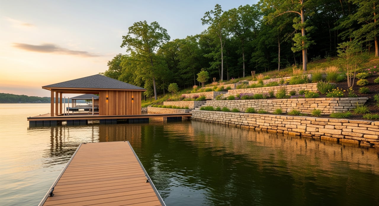
Private docks and lifts
Most private docks and related structures need Corps authorization. Typical conditions address location, size, construction details, mooring, and safe marking for boaters. Permits are usually revocable and can include maintenance, insurance, and removal requirements if a dock is abandoned or noncompliant. Some areas may allow seasonal or year-round placement depending on the SMP and navigation needs.
Vegetation management
Trimming or clearing vegetation on Corps-managed shoreline is regulated. Minor safety trimming may be allowed, while larger clearing or landscaping is restricted or may require mitigation. The Corps prioritizes native vegetation for erosion control, habitat, and water quality. Permits can specify how much area you can clear, what tools you can use, and whether you must replant.
Access improvements
Small features like steps or narrow footpaths may be allowed with a permit. Larger or hardened work, such as wide stairways, concrete ramps, or retaining structures, triggers more review and must meet specific standards. Erosion control, like riprap or revetments, often needs engineered plans and, in some cases, state permits in addition to Corps authorization.
Buoys and mooring devices
Buoys, mooring balls, and similar devices are regulated to prevent navigation hazards and preserve public access. Placement, number, and markings may be limited by the SMP or by site-specific conditions.
Other activities that need approval
Beach creation or fill, dredging, boat ramps, utilities crossing project lands, and temporary construction staging on Corps property typically require review and authorization.
How the permit process works
Application basics
You submit a shoreline use permit application to the Table Rock Lake project office. Plan to include a site plan that shows your project in relation to the high-water mark and nearby facilities. Provide construction details and show how you access the site from your upland property.
Review timeline
Simple requests that meet the SMP may finish in a few weeks to a few months. If your project involves dredge or fill, sensitive habitat, or cultural resources, it can take longer due to added consultation and coordination with other agencies.
Fees and terms
Shoreline permits often include an application fee and, in many programs, an annual use fee. Terms vary by reservoir and can be short-term, annual, or multi-year renewals. Always confirm the current Table Rock SMP and fee schedule with the project office for exact details.
Transfers when a home sells
Many shoreline permits are revocable and require Corps approval to transfer. If you are buying a home, ask the seller for copies of any permits, inspection reports, and proof of recent fee payments. Confirm with the project office whether a permit can be transferred and what steps are required.
Environmental and legal checks
Some projects can trigger federal laws. Dredge or fill often requires review under the Clean Water Act. Work that affects navigable waters can involve the Rivers and Harbors Act. The Endangered Species Act and the National Historic Preservation Act may apply if protected species or cultural resources could be affected. You may also need state or local permits, including water quality or floodplain approvals.
What this means for your purchase
A dock or shoreline improvement may be possible, but it is not guaranteed by owning waterfront property. Your authorization comes from the Corps and is subject to the SMP and site conditions. Permits are generally revocable and include compliance requirements. Plan with this in mind so you are comfortable with both the benefits and the limits that come with lakefront living at Table Rock.
Due diligence checklist for buyers
- Request from the seller:
- Copies of all current Corps shoreline permits, drawings or maps, and any transfer paperwork.
- As-built photos or drawings of docks, stairways, riprap, and cleared areas.
- Records of Corps inspections, notices, or correspondence.
- Any insurance claims or damage history from storms or high water.
- A survey showing property lines, the high-water mark, and any project boundary or easement.
- Ask the Table Rock Lake project office:
- Whether the shoreline next to your parcel is under Corps control and whether an existing authorization applies.
- The current SMP and fee schedule, plus any recent amendments.
- Permit history for the location, including conditions or past violations.
- Process and timeline guidance if you plan new work like a dock, riprap, or vegetation management.
- Check other stakeholders and rules:
- County records for easements or rights-of-way to the shore.
- Local zoning, permitting, and floodplain rules in counties around Table Rock Lake.
- Missouri and Arkansas state agencies for boating, water-quality, and fish or wildlife rules.
- Inspect on site:
- Verify the high-water mark location relative to improvements and your upland boundary.
- Look for Corps signage or other markers indicating inspections or conditions.
- Note any apparent encroachments or unauthorized clearing that could require correction.
Where to find official rules
- Table Rock Lake project office. This is your primary source for the SMP, permits, fee schedules, and site-specific records.
- U.S. Army Corps of Engineers district and regional pages. These explain SMP policy and may host documents for Table Rock Lake.
- Property deed and county offices. Confirm boundaries, easements, and any recorded agreements.
- State agencies in Missouri and Arkansas. Check for permits related to water quality, fisheries, wildlife, and boating.
- Local planning and permitting departments. County-level rules for grading, septic, and floodplain can affect your project.
Always confirm you have the most current SMP and fee schedule from the Table Rock Lake project office before making decisions or submitting applications.
Pro tips to keep your dock project on track
- Start early. Contact the project office before you write offers or bid work.
- Map it right. Mark the high-water line and nearby facilities on your site plan.
- Hire experienced help. Use contractors familiar with Corps standards and local conditions.
- Keep records. Save all drawings, emails, and inspection notes so transfers go smoothly later.
- Plan for care and coverage. Budget for maintenance and discuss insurance with your agent.
- Protect the shoreline. Do not clear vegetation or stage equipment on Corps land without authorization.
- Have a backup plan. If a dock is not possible, consider community docks or alternative access.
Ready to search lakefront homes?
If you want a clear plan for dock options, vegetation rules, and shoreline access before you buy, we can help you navigate the process. Get local guidance from a broker-led, boutique team that understands Table Rock Lake’s SMP and how it affects real buyers and sellers. Let’s talk about your goals and map a smart path to the water with Dean Coder.
FAQs
Who owns the shoreline at Table Rock Lake?
- The U.S. Army Corps of Engineers manages the project lands and lakebed, so private upland owners typically do not own the shoreline or submerged lands.
Can I build or move a dock on Table Rock Lake?
- Possibly, but you must apply to the Corps and meet the SMP’s location, design, and safety standards; approvals vary by site and conditions.
Are shoreline permits permanent at Table Rock Lake?
- No. Many permits are revocable and require renewal or can be rescinded for public need or noncompliance.
Do I need state permits for shoreline work?
- Often yes. Work affecting water quality, habitat, or navigable waters may require state approvals in addition to Corps authorization.
Will a dock permit transfer when I buy a lake home?
- Sometimes. Transfers usually require Corps approval and documentation, so request copies and confirm transfer steps before closing.
How long do Table Rock permits take?
- Simple approvals may take weeks to a few months, while projects needing environmental consultation or agency coordination can take longer.